-40%
Coso mines, Owens Valley, Ridgecrest, Calif; RARE old 1st ed, BIG pullout maps !
$ 28.91
- Description
- Size Guide
Description
Rare 1943 first edition describes and maps Cosomines, near Owens Valley, Ridgecrest, Inyo, CA
Remote hot springs were known to early miners headed to Death Valley
Describes area
before
the Navy took over and built geothermal plants
T
he closest you’ll probably ever get to experiencing this famous area is by reading this 71-year-old first-edition report.
No, the site is not atop some inaccessible peak. In fact, the deposit — with its "hot springs and fumaroles, from which acid water and steam are still issuing" — is remote but
easily reached by paved road. It's in Inyo County, California, only a few miles east of heavily traveled U.S. 395, at the Coso Junction turnoff, between Little Lake and Haiwee Reservoir (Olancha).
But the area is off limits to the public, locked behind barbed wire and guarded gates, inside the boundaries of the China Lake Naval Air Weapons Station, which sprawls northward over hundreds of square miles of mountains and desert from Ridgecrest, California, to within a few miles of the western boundary of Death Valley National Park.
Favorite resting spot for miners in 1870s
Long before the navy took over the site, nearby Coso Hot Springs was a favorite rest stop in the 1870s for tired miners on their way to rich silver strikes in the Cosos and to the infamous rough and-tumble mining town of Darwin (once called "New Coso"), just on the other side of the Coso Mountains. Historian Richard Lingenfelter says that the springs were also known to the earliest miners and explorers heading for Death Valley and Panamint Valley.
Maps are well worth the price alone
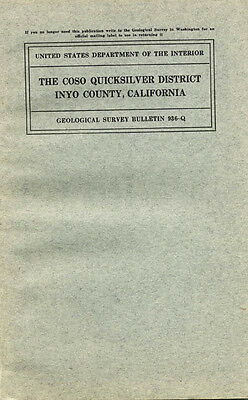
Even if you could visit these mercury mines, they would be radically different from descriptions in this nine-by-5.75 inch report (cover, above right); therein lies its historic value. The navy built a huge geothermal electric generating plant to harness the steam power of Coso Hot Springs, forever changing the landscape. This 31-page report and four maps (two foldouts, one full page, one in pocket) are one of the few geologic records of how it once was, back in the days when sulfurous steam shot from vents around the "Devil’s Kitchen" section of the quicksilver district. The maps are well worth the price alone if you're a collector of Inyo County memorabilia, even if you could care less about area geology.
Condition of the report —
The Coso Quicksilver District, Inyo County, California
— is very good with some very slight yellowing to inside pages. No rips. Cover and map in the back pocket have some slight rippling. Lower left corner of report is a little bent. Also be aware that the typesetting for this book is a bit crude, almost looking as if the printing plates were made from typewritten pages.
The maps:
1.
Index Map of Southern California
; fold out, black and white, shows district’s location in state (the one ho-hum map in the bunch).
2.
Geologic Reconnaissance Map of the Coso District and Vicinity, Inyo County, California
; fold out, two-color vintage map (small detail above) shows district’s location off a then-featureless US 395; shows Little Lake (still with train service!), Rose Valley, northern section of Indian Wells Valley and Coso Junction.
3.
Geologic and Topographic Map of the Wheeler Prospect and Vicinity, Inyo County, California
; full page, two color.
4.
Geologic and Topographic Map of the Coso Quicksilver Property, Inyo County, California
; two-color, in pocket, about 20 by 22 inches; contour interval is 25 feet, two inches = 1,000 feet (detail of small map section, photo below).
Where is it?
The Coso Quicksilver District is in southern Inyo County, near Coso Junction, off Route 395, the main north-south highway through Owens Valley from Inyokern, California, to Mammoth Mountain, California, and Reno, Nevada. The mines are 169 miles northeast of Los Angeles and 128 miles from Bakersfield, California, in Kern County. Counties adjacent to Inyo County are Mono, Fresno, Tulare, Kern and San Bernardino.
The book:
The Coso Quicksilver District, Inyo County, California
; Geological Survey Bulletin 936-Q, by Clyde P. Ross and Robert G. Yates, pp. 395–416, 31 pages plus two contents pages and four maps, stiff paper covers, nine by 5.75 inches, stapled binding, Department of the Interior, United States Government Printing Office, Washington, 1943, very good condition except for some slight rippling and yellowing to maps and interior pages.
We have many MANY more rare mining books! Just visit our ebay store, Rare Mining Books:
http://stores.ebay.com/Rare-Mining-Books?_rdc=1
Payment methods and domestic shipping
Paypal only. Shipping and handling via priority mail. I pride myself on bulletproof packaging and ship in sturdy cardboard boxes or reinforced envelopes.
The fine print:
Feel free to contact me if you have any questions about the item or terms of sale.
I post feedback once a week. Not responsible for typographical errors.
Nearby counties
Counties adjacent to Inyo are Mono, Fresno, Tulare, Kern and San Bernardino; nearby counties include: Riverside, Orange, Los Angeles, Santa Barbara, Kings, Madera, Mariposa, Tuolumne and Alpine.
Towns, population areas and interesting sites in or near Inyo County include Aberdeen, the Alabama Hills, Ancient Bristlecone Pine Forest, Argus, Badwater, Ballarat, Big Pine, Bishop, Bullfrog, Cartago, Cerro Gordo, China Lake Naval Weapons Center, Cottonwood Lakes, Coso Junction, Darwin, Death Valley Junction, Dolomite, Dunmovin, Eureka Sand Dunes, Fossil Falls, Furnace Creek, Greenwater, Haiwee Reservoir, Independence, Inyokern, Keeler, Laws, Lake Sabrina, Little Lake, Lone Pine, Mt. Whitney, Olancha, Owens Lake, Onion Valley, Panamint Springs, Pearsonville, petroglyphs, Rhyolite, Saline Valley, Scotty's Castle, Shoshone, Sierras, Sierra Nevada, Stovepipe Wells, Swansea, Trona geology mining mines stock certificate, Tecopa, Ubehebe Crater, Whitney Portal.
Good luck and thanks for bidding!
Track Page Views With
Auctiva's FREE Counter
